Check out how much more snow is on the ground south of the Twin Cities than in the immediate metro area. The dark blue shaded counties have as much as 10-14″ of snow, compared to 8-12″ in the immediate Twin Cities area.
 Average high in the Twin Cities for Feb. 3: 24 F. Today’s predicted high: 25.
We’re in-between. The worst of winter (in terms of hours below zero) are behind us. Yet it’s way too early to even contemplate spring (although daydreaming about spring break is encouraged. If you’ve lived in Minnesota longer than 1 winter you know the cold, cruel truth: much of February and March is one step forward, two steps back. Temperatures climb to “average” today, a recognition of the fact that the sun is climbing ever-higher into the southern sky. In fact today the sun is as high in the sky as it was back on November 9, when the high in the Twin Cities was a balmy 61. The reason it’s so much colder in early February: all that snow on the ground across Canada and the northern third of the USA. It acts as a “refrigerant”, chilling the air from below, keeping us 20-25 degrees colder than we would be otherwise. Until we lose the snow (late March, early April, your guess is as good as mine) the sun’s energy will go into melting snow instead of heating up the air, limiting just how mild we can get. That said, the prevailing jet stream winds make a huge difference. Are prevailing winds originating from the Yukon or Vancouver? For at least the next 36-48 hours you’ll feel a distinct Pacific influence, coaxing the mercury well into the 20s to near 30 in some Minnesota towns. Hardly spring fever, but a baby-step in the right direction.
Snowfall potential.
Models are still hinting at a coating to 1″ of slushy snow (mixed with a little freezing drizzle at times) by Friday. This will be a heavier, wetter snow, nothing like the fluffy, powdery snow that fell on Monday. For a final list of snowfall amounts from Monday’s “storm” (the old timers are laughing now) see below. Flurries taper early Saturday before another surge of light snow arrives Sunday and Monday, this time light, fluffy and powdery, as temperatures fall through the teens. That could mean more spin-outs and fender-benders the latter half of the weekend, even though the models are only printing out 1-2″ of snow Sunday and Sunday night. The mercury tumbles early next week, at least 3-4 days with highs in the teens, low in single digits to just below zero. The bottom line: this next cold snap won’t be as harsh as what we just muddled through, nothing like the first third of January, when we shivered through at least one night of -25 F. air temperature. The good news: we warm up fairly rapidly the latter half of next week, more 20s by Thursday/Friday, even some low 30s by the second weekend of February. Not exactly spring fever, but Old Man Winter shows some definite signs of mellowing in the weeks to come.
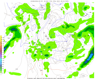
 1-2″ of Minnesota powder next Sunday – Monday? Here’s the GFS model output valid Sunday evening at 7 pm, showing expected snowfall from 1 pm to 7 pm – hinting at the heaviest amounts over southern MN, south of the Minnesota River. With temperatures in the teens this should be a light, fluffy, powdery snow – similar to Monday’s snowfall. Translation: more ice & snow-covered roads and a greater chance of traffic hassles.
No big storms, no headline-grabbing outbreaks of numbing air, just a nuisance snow Friday, maybe an inch or two of new snow Sunday into Monday morning to cover up the grit and grime. With Monday’s fresh coating of white snow conditions are pretty good statewide, and they’re about to get a bit better. Not exactly Aspen/Snowmass conditions, but not bad at all for Minnesota.
 How to survive an earthquake. Along with hurricanes, this is one of the few natural disasters Minnesotans DO NOT have to worry about! But many of us travel to earthquake-prone regions, like California and the Pacific Rim. Even Seattle and Memphis are vulnerable to potentially devastating quakes. In the unlikely event the earth under your feet ever shakes uncontrollably you may want to know what to do to increase your odds of survival. Time magazine has a great feature story here.
Paul’s Outlook for the Twin Cities
Today: More clouds than sun, a bit milder. Winds: SE 5-10. High: 25
Tonight: Patchy clouds, not as cold. Low: 15
Thursday: Mostly cloudy, a little light snow/ice possible by Thursday night. High: near 30
Friday: Period of light snow, mixed with freezing drizzle. A light, slushy accumulation possible. High: 29
Saturday: Flurries taper off – improving travel, turning colder. High: near 20
Sunday: Cloudy with more light snow, potential for an inch or 2″ by Monday. High: 18
Monday: Light snow tapers, slowly improving travel conditions. High: 15
Tuesday: Some blue sky, chilly. High: 17


