

It’s invisible. It’s scary. It’s no one’s problem.
That’s a bad combination for a potential natural disaster that could significantly change the Mississippi River through the Twin Cities and deny Minneapolis a beloved tourist attraction. What does Hennepin County emergency management director Eric Waage call the wall buried beneath the bed of the Mississippi River, a hidden wall that supports St. Anthony Falls?
“The Orphan Hazard.”
The phrase was part of the lobbying effort by a handful of individuals and organizations to convince the 2023 Legislature to set aside money to assess the condition of what is known as the cutoff wall and then estimate the damage that could result from its failure.
“This is a hazard we don’t know enough about yet,” Waage told the Senate State Government Committee. “We don’t understand it fully.”
[image_credit]John O. Anfinson[/image_credit]

[image_caption]Eric Waage[/image_caption]
“It’s everybody’s and nobody’s problem,” said Colleen O’Connor Toberman, land use and planning program director for Friends of the Mississippi River.
“Rivers are dynamic systems and it is an act of hubris to locate a city along one and expect it not to change,” said Carrie Jennings, the research and policy director of Freshwater.
Presentations from groups including the Friends of the Mississippi River and Freshwater were so effective that the appropriation in the state government budget exceeded the request by a quarter of a million dollars. Over the next two years, the St. Anthony Falls Lab at the U of M will direct a physical assessment of the hidden wall, examine the geology of the riverbed and banks and begin to estimate what would happen if it all breaks apart.
While the study will provide greater clarity, those who have attempted to guess the results of a failure agree on one thing: It would be bad. Very, very, bad. What are the possible things that could go wrong if the wall fails?
- St. Anthony Falls could collapse, and the river would eventually scour a new path.
- The level of the Mississippi River could drop dramatically.
- Crossings over the river and development on its banks would be threatened.
- A huge part of the region’s water supply could be disrupted if the river level dropped below the intake pipes.
Waage said while these scenarios haven’t been fully studied, an Army Corps of Engineers report about the possible impact of removing the recently-closed lock and dam facility at St. Anthony Falls provides a hint at what it could mean.
“The falls would disintegrate into rapids if the dam were to be removed without extensive stabilization,” the Corps report stated. “A head cutting erosion would extend far upstream, affecting roads, bridges, houses and other infrastructure.”
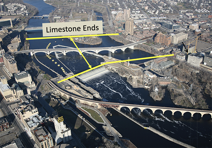
The wall’s origins
Ulysses Grant was president of the United States when the Army Corps of Engineers built the 1,850-feet wide, four-to-six-and-a-half feet thick structure that starts beneath the bed of the river and sinks more than three stories into the sandstone layer below. While the horseshoe dam upriver from the falls and the apron and spillway structure at the falls hold back the river, the cutoff wall supports the brittle limestone beneath both.
It is that unseen foundation upon which all that visible infrastructure rests. And it became necessary after human meddling with the geology of the river went awry. Mill owners used water power to drive their machinery, having dug tunnels to channel that power to their mills and then back to the river downstream.

[image_credit]John O. Anfinson[/image_credit][image_caption]The first is Platteville limestone. The limestone tapers from 8 to 12 feet thick at the downstream edge to only 2.5 feet at the upstream end. The river has cut away the Magnolia and Hidden Falls members. Only the Mifflin and Pecatonica remain in the river.[/image_caption]

[image_credit]Courtesy of the Minnesota Historical Society[/image_credit][image_caption]Break in the tunnel at St. Anthony Falls on October 5, 1869.[/image_caption]
A variety of repairs were attempted over the next few weeks with construction of three cofferdams that blocked the area of the break providing a short-term repair. But further breaks resulted in the Army Corp of Engineers winning congressional funding to build the cutoff wall and the concrete apron spillway. (Corps archeologist Brad Perkyl describes the collapse and rebuilding in this video.)

[image_credit]John O. Anfinson[/image_credit]
“The cutoff wall stopped the clock,” said John Anfinson, the former superintendent of the Mississippi National River and Recreation Area. “The falls is an ancient but not immortal character.” Geologic studies begun in the second half of the 19th Century determined that the falls were once in what is now downtown St. Paul. Over a period of 12,000 years, the erosion of the limestone layer moved the cataract 15 miles upriver to where they now stand — barely.

[image_credit]John O. Anfinson[/image_credit][image_caption]Completed in 1858, the horseshoe dam accelerated the retreat. At the pace the falls receded between 1857 and 1868, they would have ended in just 40 years.[/image_caption]
The Corps’ intervention not only preserved the falls, it likely made Minneapolis into the city it became: the flour milling capital of the globe, thanks to the water power derived from a 50-foot drop in elevation.
But once the cutoff wall was completed in 1876, it was forgotten.
“Once it stabilized the falls, it sort of dropped off everyone’s radar,” Waage said. “And it’s been sitting that way ever since.”
‘Too serious of an issue’
Anfinson knows the Mississippi River well. For 20 years he worked with the Mississippi National River and Recreation Area, including as superintendent from 2014 to 2020. Before that, Anfinson spent 20 years with the Army Corps of Engineers, St. Paul District, as the district historian and the chief of the district cultural resources staff.

[image_caption]John Anfinson[/image_caption]
“Most of the people I talk to don’t get this issue,” Anfinson said. “Even if I try to explain it in great detail, standing on the Stone Arch Bridge, looking upriver at the falls, people still can’t get it.”
O’Connor-Toberman said supporters of the assessment took Anfinson’s presentation on the road to “every layer of government, trying to get someone to take responsibility and provide some leadership here. No one wanted to until Hennepin County got involved and then some key champions in the Legislature.”

[image_caption]Colleen O’Connor Toberman[/image_caption]
“Once she saw that, she got it and knew something had to be done,” Anfinson said of his presentation. “If that wall failed during an event like this spring with 66,000 cubic feet per second, the falls would evaporate. It would be gone. And I don’t know if we could get control of it in any way before the damage was done.”
Klevorn recalls her first thought when she was shown the presentation was “Oh, my gosh.” She had worked with Friends of the Mississippi River on other issues and was interested in hearing about this problem when they approached her last year.

[image_caption]State Rep. Ginny Klevorn[/image_caption]
Klevorn said that while the supporters asked for $750,000, she included a million because “the last thing you want to do when you’re in the middle of this is to run out of funding.
“It’s too serious of an issue to try to do on the cheap,” Klevorn said. “A million dollars when you’re looking at a potential colossal failure of this magnitude? We would look foolish if something occurred.”
The power of water
While water power isn’t an economic driver anymore, the river is an attraction for both residents and tourists, and billions of dollars of development of residential and recreational investments have been built on its banks.
[cms_ad:x104]
What could trigger a failure? Certainly high river flows such as happened this past spring. Anfinson said that river flow reading of 66,000 cubic feet per second was the fourth highest recording ever for that location. Gradual seepage of water beneath and through the cutoff wall could weaken the natural foundation as well.
Anfinson said he is especially concerned about the bridges upriver and downriver from the falls. Some of the piers of the 3rd Avenue Bridge, currently being renovated, rest on limestone.
“If that limestone is undermined at all, the piers will punch through it like paper,” Anfinson said. In addition, the intake pipes for the water supplies for a million people as well as the airport are higher than where the river level would fall should the falls collapse. The Minneapolis system has only three-days-worth of storage.
The iconic Stone Arch Bridge is just downriver. Even the St. Anthony Falls Lab building where much of the study work will be done is at risk. Xcel has a hydroelectric facility at the falls.
“Some people say I’m fear-mongering,” Anfinson said. “But it’s realistic in my mind.”
Anfinson said the study managers will likely commission a geophysical analysis by a private company to use ground penetrating radar to see into the wall and the sandstone surrounding it. He termed it “basically an MRI of the wall and the geology around it.” The lab would also conduct a risk assessment by building models of the area and subjecting them to what might happen from different types of failures. Emergency management experts would estimate what risks to infrastructure and residents might result.
“Are we at risk? Do we have an emergency waiting to happen here? Is there an inevitable crisis coming?” is how O’Connor-Toberman describes the mission of the assessment. The plan is for a final assessment to be complete in two years. But she said there could be preliminary findings before then.
If the assessment finds reasons to be worried about a collapse, policy makers would then have to determine what to do, what it would cost and who would pay for it.
The Corps is at the falls because it built and operated the big navigation lock in 1963. Once that lock was closed to navigation in 2015 as a way to stop the upstream migration of invasive carp, the Corps’ reason for operating the facility went away. While it has a small role in managing river flows — mostly to open the locks at high-water-flows to relieve pressure on the river as it did this spring — that could be taken over by another entity.
The Corps is currently conducting what are called disposition studies on the upper and lower locks to decide whether the federal government still has a role and, if not, what other entity should own and operate the land.
“The Corps is looking for someone to hand the keys to,” Hennepin County’s Waage said.
Nate Wallerstedt is the project management branch chief for the Corps’ St. Paul District.
“From the best we can tell, the Corps doesn’t own (the cutoff wall),” Wallerstedt said. “We don’t have authority to work on it. There is no appropriation to do so.” Still, it did ask the Corps’ engineering and design center in Vicksburg, Mississippi, to suggest a way to examine the buried wall. But it would need a non-federal partner to work with and pick up the estimated $5 million cost. None stepped up.
He said the Corps’ mission at the falls was reduced when the lock closed, but it is still involved in the facility and has been meeting with what it calls the facilities group — entities that own property around the falls including Xcel, the Minneapolis Parks and Recreation Board, the city of Minneapolis and the St. Anthony Falls Lab.
“We share information about emergency action plans, who to contact if something does come up,” he said. “Make a friend before you need one, kind of thing.”
Wallerstedt said he expects the Corps will be helpful with the study and said that the management of the work is “in the wheelhouse” of the St. Anthony Falls Lab. And if, in the future, Congress decides the Corps should be involved in any response to the study, it will step up.
What’s next?
Waage said the assessment will determine how stable the cutoff wall is, how likely it is “that nature will find a way to outflank it, to get around it and what would happen if the falls collapsed.
“We want to find out what the geology looks like and if there is clear evidence of compromise of the wall itself. Are there fractures in the rock or voids that we can find that make it urgent,” Waage said. “It’s almost an intellectual exercise until we get enough data where we can quantify it properly
“It’s an undetermined hazard and it’s nothing to get too worked up about. But at the same time it shouldn’t be left unasked or unstudied,” Waage said.
The cost of a major construction project to rebuild the supporting structures for the falls in a delicate environment on top of uncertain materials would be in the billions of dollars — likely many billions of dollars. Who pays would have to be sorted out by politicians. But waiting for a failure would be more expensive in terms of dollars, legal exposure and political liability, study backers say.
“It’s a little frustrating that a lot of those relevant parties haven’t been more active in helping us resolve this because, at the end of the day, if something goes wrong and the public finds out you knew about it and chose not to act, that’s pretty damning,” O’Connor-Toberman said.


Failure to act would mean Mpls has a three day supply of water, no mention of Saint Paul but the disaster is clear, the Twin Cities would be inhabitable in days. Congratulations to the far sighted citizens and Public Servants for championing this project.
I’m not sure where St Paul gets it’s water, but the Mpls treatment plant is a mile or three upstream from the falls. So if the falls collapse & the pool drops far enough, the treatment plant could lose access to water. It’s something of a worst-case scenario; but to your point, investing in the research would be smart.
Just think if that Feeding Our Future money was put toward protecting the two downtowns.
Fantastic article describing a very hard to understand matter. Many thanks.
But how in the world can there be any doubt that the US government has authority over the cutoff wall under a federal waterway, built by the US government in 1876? Talk about the most critical “infrastructure” in the entire state!
Nice work, Peter. A complicated issue that deserves attention.
No question this is a federal matter, likely on a national security level. There are major national impacts should the wall fail and the Mississippi River drop significantly as a result. River shipping essentially stops–which means farms all over the Midwest US (and possibly well down into Southern states) have to find new (more expensive) means to get their products to market–if they are able to grow anything, because a lack of water could be a major problem along the entire length of the river. It would also push a lot of businesses out of an east-west region along both sides of the river because they rely on the water for drinking water, cooling water (for power plants–both nuclear and non-nuclear), and so on. Those people will become internal migrants, being forced to move due to an environmental change they can not control.
There seems to be a bit of a misunderstanding here. Were the St Anthony falls to collapse, there would effectively be zero impact on downstream traffic. The water flow rate will not change. The local shape of the river – specifically the channel in the area of the falls – is what will change. As the article notes, changes in that area could be dramatic and sudden. But the same volume of water will continue to flow downstream, where the next control is lock and dam number one, i.e. the Ford dam.