


I still remember the feeling of taking the Blue Line light rail for the first time in 2004. Gliding on rails high over Highway 62, looking out over the river valley, zipping toward the city, it felt like the urban future had arrived. Minneapolis, a city that had long shirked away from density, was turning a corner.
The plan was that efficient, comfortable transit between downtown and the airport would bring more people into South Minneapolis without the corollary of car traffic. Because the Blue Line was built in the middle of the wide Hiawatha corridor — featuring acres of parking lots and sparsely-used industrial land — there was plenty of room for the neighborhood to grow along with the rail traffic.

[image_credit]Metropolitan Council[/image_credit]
Things are changing. The pace of housing construction has quickened over the last few years in South Minneapolis’ Longfellow neighborhood. Within a few blocks of the 46th Street station, four miles southeast of downtown, a half-dozen new projects boasting 500 new apartments have been completed since 2019. At the corner of 46th Street and Minnehaha Avenue, a landscape that was once gas stations, parking lots, and windowless warehouses resembles a real city.
An acute housing shortage
“We’re trying to build small units in nice neighborhoods, and make them look really nice,” said Sean Sweeney, a principal at Hall Sweeney Properties, which recently opened a new 126-unit apartment building on the corner. “Most of our tenants are young people, where it’s their first or second apartment.”
Sweeney has been in the housing business for 20 years, working in California before coming to the Twin Cities. The Wakpada (Dakota for “the creek”), an apartment complex at the corner of 46th Street and Minnehaha Avenue, is the second Longfellow project he’s worked on.
All the new housing is important because the Twin Cities has the most acute housing shortage in the Midwest. According to the regional demographers, the metro needs to build 50,000 new homes to meet existing demand and keep costs from spiraling ever higher. Even with Minneapolis’ brisk pace, the Twin Cities is nowhere near that level.
The disconnect between demand and supply has long made me wonder why some parts of the city see significant new housing construction and others can go half a century without any new apartment buildings at all.
I was curious: Why did it take so long for housing to be built by the Blue Line stop? And why does housing construction seem to happen all at once?
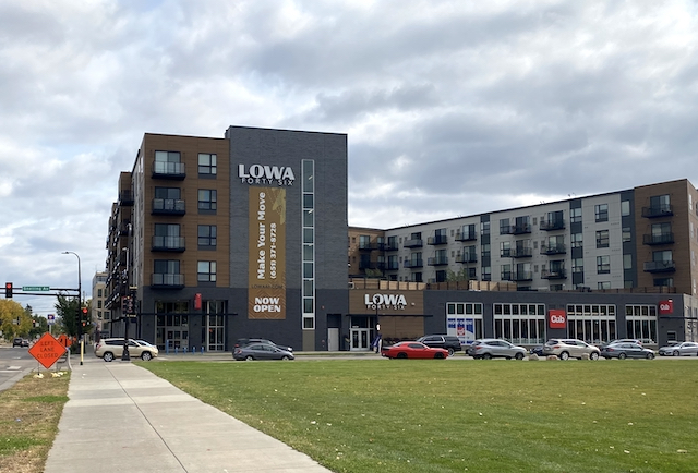
[image_credit]Photo: Bill Lindeke[/image_credit][image_caption]Lowa46 is on 46th Street between Minnehaha and Hiawatha avenues. It includes a Cub Foods grocery store at street level.[/image_caption]
To be fair to the Blue Line transit-oriented development, new housing was not completely foreign to the area. Oak Station Place, a four-story, 104-unit mixed-use project across Minnehaha Avenue, has been around for almost a decade. Elegantly wrapped around a transit station, and featuring patios and public space, it set a high bar for development in Longfellow. But it took a long time for others to follow.

[image_credit]Photo: Bill Lindeke[/image_credit][image_caption]Oak Station Place.[/image_caption]
“It really boils down to rent levels in every neighborhood,” Sweeney said. “Historically, rents in (Longfellow) were too low to justify much new construction. Few projects worked here (and so) while there were a few things built 10 years ago, you didn’t see a large boom. But area rents have grown, which allows new construction to be feasible.”
It’s true that Minneapolis rents have increased more quickly since about 2015, though not nearly as much as in other parts of the country. During that period of economic fluctuation and the housing shortage have made rents more volatile in many Minneapolis neighborhoods. If it sounds economically clinical, that’s because it is. Developers need to raise funds from investors and take on loans from banks, and the rent numbers, along with data from nearby projects, allow that to happen.

[image_credit]University of Minnesota Center for Urban and Regional Affairs[/image_credit][image_caption]The line in the chart shows the average increase in rent for Minneapolis apartments. The shaded area is the range of changes in rents.[/image_caption]
Less car-dependent
The other promising trend for South Minneapolis housing is that the parking to unit ratio is going down, which is good news for the climate. The Wakpada only has 73 parking spots, much less than one spot per apartment. That represents a big change from how buildings were designed and marketed in the past.
“I’ve been doing this for 20 years, and it used to be that if you didn’t have at least a parking spot for every unit you weren’t going to lease those units,” Sweeney told me.
The fact that a development, this far out of downtown, can be successful with so little parking is a good sign if Minneapolis wants to achieve its ambitious climate goals. And because the average parking spot costs over $30,000 to construct, reducing parking allows the rents to go down, which is especially appealing for tenants these days.
“Life in Minneapolis is still mostly car dependent, but it is starting to change,” Sweeney said. “People are beginning to understand the benefits of walkability and transit.”
While the bulk of the new construction has been centered around the downtown and University of Minnesota campus areas, some of the development has begun to expand outward into Minneapolis’ traditionally single-family areas. The zoning changes made by the city’s 2040 Comprehensive Plan make this kind of infill density even more likely to occur.
But that requires investors and developers eager to build on Minneapolis’ parking lots and gas stations. And if Sweeney is right, those days might be coming to a slow halt. Inflationary costs, the labor shortage, and a slowing real estate economy due to higher interest rates is having an effect, and Sweeney sees the pace of construction slowing down.

[image_credit]Photo: Bill Lindeke[/image_credit][image_caption]Wakpada apartment building recently opened.[/image_caption]
Most likely, housing will continue at a slow pace, not as much as the city needs. Sweeney and his partner are now working on a 204-unit housing development on 36th and Nicollet, on the former site of an auto parts strip mall. In its place will be a six-stories of apartments, set to begin leasing in about a year.
“The good and bad of working here is that it’s a very steady market,” Sweeney told me. “You don’t have huge (price) increases, but the bottom rarely falls out either. Some other places boom and bust, (but) this a nice place to be a developer.”


I wondered if having a budding LRT network helped spur. Once the Green Line opened, suddenly the Blue Line was now more than back and forth. The Green Line opened up a transfer to University Ave neighborhoods and St. Paul (and the sites along them).
But developers probably aren’t paying that sort of attention on where and when to build.
I think the A Line was even more helpful for these examples. IT stops right in front of almost all of these buildings, and it’s a terrific piece of useful transit.
Bill, I totally agree and thank you for highlighting the development in this area of the city. The addition of the A line has been a great addition to the transportation options in this neighborhood. I have used it, along with the Blue Line, many times and its fantastic. The A Line is also a great way to get to the Minnesota State Fair each year too. Two notes here about the locations you named in the title of this article. This neighborhood area along 46th Street in south Minneapolis is named Hiawatha, not Longfellow. The Longfellow neighborhood is located further north, along Lake Street. The Oak Station Place development you mention in the article is actually located at 46th Street and Hiawatha Ave, not across Minnehaha.
It’s pretty clear that planners of the Blue Line had a good mass transit connection between central Minneapolis and the airport and Mall of America as their primary objective. And they sensibly routed the line along a highway, affording reasonably good train speed with minimal construction expense and dislocations. (Granted, it’s regrettable that over- or underpasses were not created for vehicles and pedestrians at major street crossings, and also short-sighted that the downtown tracks did not go subterranean.) The line has not particularly stimulated housing development; after all, much of the route passes through industrial areas on one or both sides of the tracks, not places well served by grocery stores or the like and maybe lacking in easy bus connections. But now we have increasing demand for urban housing plus higher rents as noted.
In contrast, the Green Line was routed on a busy arterial street–rather than along I-94–by Ramsey County and St. Paul politicians who hoped to stimulate development at five intersections in St. Paul, which meant that the train could only operate at a snail’s pace compared to other light rail lines built around the country during the last 50 years. They and their planners seemed oblivious to the difference between a train and streetcars. The present leaders like to call attention to the housing development that has occurred along the line, much of it within easy commuting distance of the University of Minnesota main campus and downtown Minneapolis, development that might very well have happened anyway along the serviceable bus line superseded by the Green Line. And most of that St. Paul development pays taxes and a relatively low rate, compared to the commercial/industrial property it replaced: an apparently overlooked consequence.
Not that leaders in Minneapolis as well have avoided a certain boutique city mentality.
Hard to believe development would be so slow given the absence of rent control. It’s almost developers make choices of some kind where to build?