One evening in May of 2018, dozens of people gathered near the corner of Summit Avenue and Dale Street to ride bicycles en masse down Summit’s well-used bike lanes. It was a memorial ride for Alan Grahn, a 71-year-old retired upholsterer who had been killed by a turning school bus driver while bicycling down Summit a few weeks before.
Memorial rides are never fun. Everyone rides in silence and you spend much of the time contemplating vulnerability, the everyday sense that any moment crossing a busy street could be your last.
It was not a coincidence that Grahn was killed a block away from where a 51-year-old woman named Virginia Heuer had died a decade earlier, also hit by a driver. The inconvenient fact is that Summit Avenue is both one of the city’s most popular bike lanes and also badly out of date, lacking many of the safety improvements commonplace in other cities.
All that could soon change, as the century-old street is due for reconstruction next year. It gives St. Paul a golden opportunity to improve the street for the next generation and turn Summit Avenue into the kind of asset that it was a generation ago.
A top bicycling route
It’s a little known fact that the Summit Avenue bike route is older than many of the mansions along the street. It appears as a key route on the 1899 map of the St. Paul Cycle Path Association and is marked as a park path on the first St. Paul Parks maps from 1909.

That’s ancient history, long before private motor vehicles took over city streets. Another fun fact is that the Summit Avenue bike lane is the oldest striped bike lane in Minnesota, dating back to 1992.
At the time, in-street bike lanes were a new thing in the state, in an era when “vehicular bicycling” was still the norm. There were often heated debates about whether bike lanes improve safety, or whether people were better off “taking the lane” and cycling amid drivers.
“If this is a roaring success, you will see more of it,” a St. Paul traffic engineer told the Star Tribune, referring to the then brand-new idea of striping paint just for bicycles.
Well, it was, and we have. For decades, Summit Avenue has been one of the top bicycling routes in the city, second in citywide traffic counts only to the paths along the Mississippi River Boulevard. But a lot has changed about traffic engineering since 1992, and today’s designs leave a lot to be desired.

[image_credit]Courtesy of the Minnesota Historical Society[/image_credit][image_caption]An image from the 1890s showing Summit at Snelling Avenue, looking east.[/image_caption]
The intersections are also problems, as turning traffic around Summit Avenue has led to repeated crashes. After Alan Grahn’s death, the City Public Works department added buffers to one portion of the street, where the car travel lanes were an absurd 19’ wide, far larger than a freeway lane (and entering Kramer from Seinfeld territory). The city painted a 4-foot buffer between the bike lane and passing cars, but there’s still a lot of room for improvement, literally and figuratively.
A crumbling street
The other truth about Summit Avenue is that it’s in terrible shape, one of many St. Paul streets in desperate need of expensive reconstruction. As any city driver knows, you can only patch potholes for so long before the foundation itself starts to erode, and the asphalt becomes an almost fractal surface.
So it’s a relief that the crumbling Summit Avenue will be fixed in 2023, giving city engineers carte blanche to redesign its features. As with the recent projects in Minneapolis, the reconstruction is a once-in-a-lifetime opportunity to start from scratch with the street layout.
“It’s our premiere bike street,” said Andy Singer, the co-chair of the St. Paul Bicycle Coalition. “Since they’re rebuilding it anyway, we should discuss putting the bike lane back in a different way, because it won’t cost anything [extra].”

[image_credit]MinnPost photo by Bill Lindeke[/image_credit][image_caption]Ice and snow in the bike lane on Summit Avenue.[/image_caption]
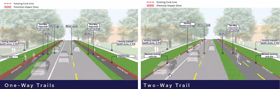
Which design is better is something I go back and forth about: In general, one-way designs are safer, but the two-way path is easier to maintain in winter. A lot depends on the details, such as what happens at intersections. Importantly, neither design would expand the existing roadway, with the extra room coming from narrowing the crossing width and removing some on-street parking.
About those trees …
I grew up a block off Summit Avenue, and have biked its length hundreds of times over the years. I can also recite a litany of historic facts about the street and how it became a row of mansions as the city expanded west with the streetcars.
During an online meeting to discuss the new street designs this week, many attendees had been informed that the bike path would destroy the street’s historic tree canopy. A few weeks ago, a group called the Summit Avenue Residential Preservation Association (SARPA) sent out a letter to neighborhood residents warning that plans for the bike path “may include the removal of nearly 400 trees” east of Lexington.
SARPA, one of St. Paul’s more obscure legacy acronyms, is a relic of the George Latimer administration, dating to an era when Cathedral Hill was “in decline” and Summit mansions were being converted into apartments or institutional facilities.
Of course, the claims in the alarming letter were not true. Neither of the city’s proposals would expand the roadway, and no trees would have to be harmed. But the misinformation fueled concerns during the meeting and turned the unmoderated discussion into a chaotic shouting match, an unfortunate turn of events for folks who want a safer street.
Back in 2018, when the cyclists gathered to remember Alan Grahn, someone in an SUV began honking their horn furiously and revving their engine at the passing cyclists blocking the intersection. I watched Mayor Melvin Carter personally turn around and speed to the angry driver, calm tensions and explain what was going on.
It seems like this case might also require city leaders to step in and quell overreactions from folks in the neighborhood needlessly worried about the trees. Hopefully, officials can correct the record, get a safer design in place, and make sure that Summit Avenue remains a welcoming gem for the next hundred years.


I learned on that ride that the road surface was even worse in the driving lanes than in the bike lanes.
The drawings above pertain only to the roadway east of Lexington, where traffic is two-way. What would be intended west of Lexington?
As a lifelong bicyclist (and a driver), I find separate two-way bike lanes to be far more dangerous than any other design, as they multiply the directions in which traffic may approach at an intersection, present that traffic in counterintuitive ways, and confuse questions of right of way.
One-way lanes separated from auto lanes by parking/curbing is OK in that regard, but in my experience does little more than make turning vehicles more oblivious to bicyclists about to cross the intersection. Also, it is likely that those implementing the design will festoon the bicycle lane with stop signs at street crossings where travel along Summit itself is not impeded, making it much more efficient just to bicycle on the roadway, where there no longer will be a separate lane. So the actual result might be more bicycle-auto conflict and more risk of bicycle-auto collisions.
Summit west of Lexington seems just fine as it is. The setting, separated vehicle travel lanes and limited traffic signals promote calm vehicle travel and the bike lane is wide and visible. Just reconstruct the surface and plow properly in the winter, and all is good.
I share some of your concerns about the two-way lanes, but having been a daily user of the similar paths on Como and Wheelock, I’m much more in favor of them now. Good design decisions like tabled crossings and open sight paths make it fairly easy for cars and bikes to see each other with plenty of time to react.
The only area where the two-ways are a little more dicey are the bigger intersections. I feel like a few minor additions like bicycle signals or leading pedestrian intervals could solve that at signalized intersections. There are a few other intersections where I’m not sure what the solution would be (Wheelock/I-35E, Como/Snelling, etc.), but I think you’d have issues at those intersections whether it’s one-way or two-way.
Charles,
I too am a lifelong driver and cyclist and I too have adapted to the many perils of biking in the same space as cars. I also bike every day on Summit on my way to and from work. Here is why the status quo is woefully insufficient:
–It’s nearly impossible to ride Summit in winter. The lanes disappear, covered with ice and parked cars. If cycling is a year round transportation mode (which it is) then we need infra that works all 12 months of the year. The problem isn’t better plowing, it’s the design of the street combined with the city’s available equipment and the fact that park cars get in the way.
–To fight global climate change, we need many more people to choose active transportation. Not every is willing to risk their lives riding next to cars. The only way to increase cycling’s popularity is to make it safe for all abilities.
–Cars and trucks are much much bigger and heavier than they were 20 years ago. And drivers are much more distracted. We need grade separated spaces for cyclists on every throughway–Summit most of all.
Finally, I would urge you to ride Como Ave, Wheelock Pkwy, and Johnson Pkwy, where 2way trails are very safe and thoughtful. Features like closing off access to side streets and tabled crossings make the 2way trail design much safer. We need to build infra safe for all speeds & abilities, including kids and people with cargo bikes getting groceries. If that comes at the expense somehow of scorchers like me, so be it.
Agree with most of what you describe – one ways are far better safety-wise. West of Lexington there should be grade separation with raised cross-ways. Or micro-curbs like they’ve recently upgraded down blaisdell.
Was there discussion on intersection design? Raised crossways are overdue, particularly with that two-way design. Also, there should be no parking separating the bicyclists as motorists approach the intersection (or trees/other visual obstructions) such that bicyclists are not hidden from view.
Related – headed from Lake Street to downtown St. Paul tonight and am unsure of the best route to take…. Maybe someone has a suggestion here…..
West of Lexington is a much easier situation because the street doubles in size. As you can see in the photo in the article, it’s all but impossible to plow the existing bike lane in winter. About five years about I wrote a whole column on why this is the case: https://www.minnpost.com/cityscape/2016/12/minneapolis-breaking-new-ground-winter-plowing-protected-bike-lanes/
With 200′ of right-of-way and only two motor vehicle traffic lanes to work with, I would sure hope we can find space somewhere in there to install a safer bike lane, one where even kids feel comfortable, and septuagenarians don’t have to fear for their lives trying to enjoy their retirement.
It is much easier west of Lexington and that’s why I was perplexed and concerned that the St. Paul Bicycle Coalition wrote a report recommending pavement in the boulevards.
I’m less worried after reading the StarTribune article and seeing this: “Planners also “are not looking at going through the middle of the median” — the famous tree-lined “islands” of grass between Lexington to the river, she said.”
I find it ironic that a columnist so concerned about climate change so blithely dismisses the removal of 400 trees, most of which are healthy, all of which are beautiful. It is another instance of Mr. Lindeke dismissing citizen concern and failing to take the whole environment into account as he pushes biking as the only solution to our woes.
There won’t be 400 trees removed. That’s a made up number with no basis in fact.
Bill – please don’t state something as a fact if you can’t back it up. 400 trees is not a “made up” number and it absolutely has a basis in fact. Two people did a manual count East of Lex of the trees that would likely be sacrificed. I can give you their contact information if you truly are interested in getting your facts right. To be clear and for context, the city walked back from their proposal which would have impacted the trees on both sides of Summit East of Lex so the number EAST OF LEX ONLY is probably somewhere in the neighborhood of half that. But that doesn’t include ANY COUNT WEST OF LEX so the all in number is certainly much higher than 400. Please don’t continue to push out false information as though it were true. Thanks.
Today’s Pioneer Press features a letter titled,”Summit Avenue doesn’t need more pavement and fewer trees.”
Yes, St. Paul seems to be at least ten years behind any reasonable schedule for pavement maintenance, city-wide.
It’s not your imagination; I’ve seen the pavement condition index charts.
Well we spent two TRILLION dollars blowing up roads and people on the other side of the globe. We can’t have everything.
The needed resurfacing of Summit is indisputable, but there’s not a direct arrow to the proposed Summit Avenue Trail. June 2023,a half mile of the Avenue will be redone, an area from Victoria to Lexington. This has merely sped up a years long effort shepherded by the Met Council who defines what a Regional Trail is, and accesses the federal funds ( millions and millions of dollars) to build it. The St. Paul City Council will vote on it within 4-5 months, although a final design is not ready to show the public. When asked directly whether trees will be saved along the Avenue, lead landscape architect Mary Norton, would not say they will save the trees. Under either 2 way or 1 way plan, the current boulevard will lose 4 feet from present curbing, digging will add @ 2 more feet. Tree roots extend a minimum of 5 feet. These massive old growth trees that provide symmetry, beauty and benefit the environment will not survive. The Trail intersects 151 driveways, side streets, intersections from the Cathedral to Lexington. This presents safety and maintenance issues. Cyclists will be constantly stopping. What about snow removal? Grade and elevation changes of 4-6 feet in some blocks? Plans also call for a 4 ft buffer, similar to what you touted on the Grand Round east of Como. Seen it lately? It is either packed dirt or a weedy mess. Buffers and concrete paths require maintenance and that requires money. The City asked non profits to maintain our parks this summer. Andy Singer presented an elegant and easy fix to making biking on Summit safer and a whole lot easier. Swap the parking lane for the current bike lane. Many others have expressed similar ideas. 50-60% of parking will be lost under these proposals. Summit hosts visitors by the thousands at Cathedral graduations, University Club, Summit Manor, College Club weddings, colleges, churches, synagogues all require parking. These are realities, and there are many more unaddressed issues, like accessibility. Comments on the City website and on savesummitavenue.org are united in wanting the street paved for bike and car safety, restriping bike and turn lanes, calming traffic by enforcing speed limits, timing lights so bikers and pedestrians get a head start in crosswalks. Summit is a unique treasure that brings visitors from around the globe to walk, bike and drive the Avenue that is on the National Historic Register. We all want what’s best for neighbors, visitors, and the environment, and a raised curbed bike trail is not the answer.
Paragraph breaks are your friend (especially if you want people to read your very long comment). Sonja’s post below is a great example.
For the two years I lived on campus at Macalester, Summit’s bike lanes were my gateway to the rest of the cities. Basically all of my trips started and ended on it. I’d either go west to the river trail to get to Minneapolis, or east to the rest of St. Paul. I have incredibly fond memories of biking down that street in all seasons.
But it has never been as safe as it should be. A curb-protected path, in either configuration, would make an enormous difference.
I love history and I love design. Thanks for referencing the 1890 bike path. I would like to provide a little more historical context: especially to your comment that “long before private motor vehicles took over city streets.” What did cars take the street from? In 1890, the streets were “taken over” by horses: horses with carts, horses with riders, horses with carriages, horses pulling trucks. Long before Instacart, Crocus Hill Market (on Grand and St Albans) would deliver your produce by horse-drawn carriage. (Sadly, it closed a few years before they could have transitioned to app orders.) Cars took the roads from the horse, not the bike. In 1890, Summit was dirt (and manure) and the old photo you include shows the churned mess of mud — an even worse surface for biking than today’s potholed mess of pavement on Summit. The 1890 bicycle side path was a cinder “side path” (think: really fine gravel), and bicyclists paid a subscription fee to use it:
“Cyclists in the 1890s looked to create their own alternative to unimproved dirt roads: separate bicycle paths with packed gravel or cinder surfaces. The first projects created short leisure paths, financed by popular subscription” (Longhurst).
The St Paul path was short lived. Why? Because the automobile, indeed, started taking over from the horse, and the city began paving the muddy roads for them. Once Summit was paved, the cinder paths were a downgrade. Bikers have been enjoying the smooth (and recently not-so-smooth) pavement ever since, no subscription required. The main truth, not the “other truth,” about Summit Avenue today is that it is in terrible shape, one of many St. Paul streets in desperate need of expensive reconstruction.
I like reading your article, but I will confess that would have hoped that you would delved deeper into the details, rather than falling into the temptation to make this a simplistic “either/or” issue, Bill. This is a great opportunity to improve Summit Avenue. We need an “all/everyone” solution.
Opportunities are optimistic: they can fail or succeed. Details matter. Criticism can –and should– serve to make designs better. I think you have too easily dismissed the (many) problems with the proposal – euphemistically called “trade offs” in meetings. You write, “… both of which [proposed designs] would be vastly better than the existing in-street lane.” Would they, really? Vastly? Better for whom, I ask? And at whose detriment?
We can, and should, make Summit safer for bikers – and for pedestrians — and for people in cars—all/everyone—but this plan isn’t there yet. As it stands, it is not an upgrade, it’s a downgrade. It’s a downgrade for a lot of bikers, who prefer the on-street lanes to what’s proposed (for a myriad of nuanced reasons, read on). It’s a downgrade for pedestrians, whose safety and needs have not been considered at all in this planning effort. It’s a downgrade for the Avenue’s properties – from the houses of worship to the schools to renter and homeowner residents — who need all-mode access (including parking). And I, so far, the plan is a huge denial of what Summit is – a unique and amazing treasure. Summit should not get a cookie cutter design from the regional trail manual.
Importance
Summit is a defining asset to all of St Paul, the metro, and Minnesota. It is an historic landscape. It is a runner and pedestrian promenade. It had the first bike lanes in StP, and is currently #2 in St Paul behind MRB, as you note. It is the best preserved Victorian Boulevard in the nation. It encompasses not one, but two local, state, and national historic districts: yes, for the significant architecture, but also for the significant streetscape planning, from the wide boulevards west of Lexington to the luxurious 10 foot wide sidewalks East of Dale. The wide islands, symmetrically placed, are historically significant. (Trivia — did you know that the expansive green space west of Lexington was donated by property owners? Early grass roots vision from residents, that we enjoy today. It’s in the National Register application.) Summit received the APA’s “Great Street” designation in 2008, among the very first streets to receive this accolade (APA). This is a street where folks fought tooth and nail to keep the granite curbs. There is only one Summit Avenue. Summit is a great bike route—and we want it to be—but it is So. Much. More. Than. That.
So Much Summit
Summit is also doing a lot already. Not only is it a nationally important historic asset and park-like amenity — It has MTC and school bus stops. It has a middle school, a preK-8 school, a large University, a law school, social clubs, events centers, multiple preschools and daycares, the governor’s mansion AKA civil protest zone, churches, synagogues and houses and worship. Summit has a symbiotic relationship with Grand, with employees and customers and residents of Grand (and in-between side streets) who rely on Summit access—parking , bike lanes, or just like to walk it after getting an ice cream cone. How many Summit tourists then choose to dine on Grand, and how many Grand visitors enjoy Summit before or after? Summit is also home to many people, including lots of multifamily condos and apartments. Maybe at times, as you reference, that has been underappreciated. But, I’ll be frank, the multifamily and institutions created diversity in land use. They are an important component in why Summit survived: pretty much every city had a grand boulevard like Summit, and lost it. If we create hardships toward that land use diversity – because the parking hardship will be borne worse by the renters, the condos, the sober houses, the institutions—to be frank, I worry that Summit cannot survive. There’s not enough single family mansion millionaires who want live here and pay the property taxes and maintenance. And, even if there were, it would be a less vibrant, less diverse, less inclusive Avenue, in my opinion. We need to protect access for the renters, the disabled, and the diversity along Summit. I also don’t know if Grand can survive without Summit. We need to listen to stakeholders and build on our assets. These plans, with their many “trade offs”, are not doing that.
Trees & Roadway Size
Summit has great trees. Bill, you dismiss concerns surrounding caring for those trees as minimal. But at the TAC meeting, arborists and watershed professionals were concerned. And the roadway improvements on Cleveland Avenue show, painfully, that there are real concerns that the planned impact and the actual impact will be quite divergent. On Cleveland, there was a 300% increase in tree loss from planned to (KSTP).
You write, “Neither of the city’s proposals would expand the roadway, and no trees would have to be harmed. But the misinformation fueled concerns during the meeting and turned the unmoderated discussion into a chaotic shouting match, an unfortunate turn of events for folks who want a safer street.”
Have you looked closely at the proposals? (1) There’s more than two proposals—two for each section West of Lexington (four total) and three (or 3.5) for East of Lex; (2) Several of the 7.5 expand the roadway. East of Lex, the three proposals, plus a “half,” if you include the one marked as “not recommended.” One of them east end design “shrinks” the curb-to-curb by one foot, but with a huge trade off for residents in this highly dense, highly renter area. The other 2.5 increase the curb-to-curb by several feet. It’s been presented as “Hobson’s Choice” between trees and parking, but there’s more designs and better options: narrow the vehicle lane from 11 feet to 10; add that space to the bike lane and paint a buffer and better mark the bike lanes; widen the sidewalk Dale to Lexington (carefully, no damage to trees), as a slow speed promenade (as a mom, I can attest that those wide sidewalks are great for wobbly, young bikers and any biker, as long as you’re bike speed is close to human running speed ). Look at each crossing individually, and re-design to decrease conflicts and improve safety for all users: pedestrians, bicyclists, scooter and e-bike riders, and slow down the people in cars. Give them somewhere to get out of their cars: park more, drive less.
Intersections: AKA conflicts
“The intersections are also problems, as turning traffic around Summit Avenue has led to repeated crashes.” The intersections and all crossing conflicts, are the main safety problem. The proposed designs will create more conflict points. The two bike fatalities on Summit were both at intersections, and both at Snelling—well, Snelling and the “merge” intersection just east of Snelling. This master plan does not look at intersection crossings, at least not in the three drawings I’ve seen of proposed intersection designs. The many driveways along Summit effectively make each block into several intersections. They have not been shown in drawings and the challenges they present have not been considered.
Design for lower Traffic Speeds
Getting cars to slow down is a place of widespread agreement without any polarized sides. The designs actually widens car traffic lanes (in several of 7.5 designs), likely increasing car speed, rather than reducing it.
Separation by Speed & Safety
This plan eliminates the on-street lanes, in favor of a facility meant to attract “new users.” But many bikers, as noted in comments here and in the SPBC post and on engagestpaul, do not want two-lane facilities or the one-way separated facilities. If this is built, they will continue to ride in the street, and now will not have a place to do so creating more conflicts. The fast bikers don’t want to mix with wobbly kids on bikes (good choice), and don’t want all the new conflicts with side streets and driveways and new bike lane stop signs. There’s a lot of concern about e-bikes, scooters, and their speed of travel. Mixing speeds is dangerous.
Ayd Mill Bridge Lessons
I participated in the planning sessions for the Summit Bridge reconstruction over Ayd Mill. The biggest concern we heard then was not separation-by-mode, but separation-by-speed. That design process resulted in a cross section that is a great amazing balance of needs without creating giant negative “trade offs.” (There were no “shouting match” meetings, either.) The sidewalk was widened for “slow speeds” — it actually doesn’t matter if people are on a bike, older or younger, in a stroller running or walking—the key is that the sidewalk is a placed for moving “slowly” (under 7-8 mph) and has enough room to get around each other. That cross section preserved an on-road lane for “fast speeds” – so these are your commuter bicyclists, your group recreational riders, your e-bikes, anyone traveling between 10 and 25 mph, your motorized scooters. There’s a painted buffer to create separation from the drive lane, and the drive lane was narrowed to 10 feet to slow car traffic down by design to the 25 mph speed limit. The bike lane gets plowed with the street. It would be nice if the city cleared the bike lanes separately, and more often, with more appropriate equipment, but that’s not a roadway design problem. That’s a commitment the City could make and hasn’t. But all in all—it was a good all/everyone solution: it divides users by speed, uses lane width to slow car traffic speed, and enhances the pedestrian realm as well. It was a thoughtful, safe, balanced, multi-modal design. It also was an 75-100 year investment some of the new “trail” designs ignore. The two-way facility could not connect to the bridge layout without crossing vehicle traffic.
We are all pedestrians
Conspicuously absent from this planning effort has been the pedestrian experience. The St Paul bike plan notes that pedestrians begin and end every trip—bikers get off their bikes, drivers and passengers get out of their cars and we all become pedestrians. There are zero improvements for pedestrian crossings, zero for sidewalks. (The planners have at least backed away from paving a trail down the large center islands, though one of the Macalester area plans would take green space from those narrow islands.) Accessibility for those with limited mobility will be harder, crossing Summit will be harder for people on foot or in a wheelchair. And two-way bike lanes will make it harder for pedestrians to cross Summit, a decrease for pedestrian safety. (I cross Summit on foot nearly every day multiple times, and cars are better at stopping for peds than bikes.) Eliminating the parking lane on one side (proposed in several of the 7.5 designs), will increase jaywalking and atypical crossings, decrease drop off access to churches, schools and residences, and access to Summit itself–lots of people drive to Summit and get out and walk, run or bike. It will create new delivery and trash/recycling pick up conflicts. The parking lane is more than just parking, it’s also a shoulder, a flexible space for stopping or pulling over, or spreading out for bike peloton group rides, for bikes to pass one another. (The one-way roadway sections without the parking lane for West of Lexington designs even have a note about needing to verifying clearances for emergency vehicles. Yikes.)
“Special Recreational Feature” versus “Regional Bike Trail”
The City should switch from regional bike trail searching, and apply for “special recreational feature” for Summit. The name is a mouthful, but the description fits Summit so much better:
“Regional special recreation features provide unique regional recreation opportunities that are not generally found in regional parks, regional park reserves, or regional trails. Sites may also provide for the preservation, authentic presentation, and interpretation of elements of historical, cultural, archeological, or paleontological significance. The factors of public demand, public support, financial feasibility (capital and operating), county-wide or regional significance, and the inherent recreational or cultural aspects of the project will be investigated prior to the designation as a special recreation feature. They may occur within existing Park District facilities or separately.”
It too unleashes the ability to apply for pots of federal and state money, but allows for more tailored design to the specific “special feature.” For Summit, that would the historic and urban neighborhood context. The regional bike trail standards just do not fit well on Summit, they feel, frankly, very suburban in their demands for wide swaths of unusable space with multiple single use facilities. In the dense urban core, we need to share better. Slow down the cars, divide the roadway by speed, enhance the sidewalk realm, better paint for the bike lanes. We need Summit-specific designs that increase safety and honor and preserve the historic context.
Win/Win
The City’s street design manual talks about “win/win” solutions – but these proposals clearly makes losers: the false choice of trees versus parking, many existing bikers don’t like it, and pedestrians get no improvements and a much more difficult time crossing Summit in several scenarios. Thanks Bill, for your writing. I enjoy a lot of your posts, but this one needed a more nuanced read, IMHO.
I agree with your premise, Summit does need an upgrade, but what is proposed is a downgrade.
Source:
Longhurst
https://www.cambridge.org/core/journals/journal-of-policy-history/article/abs/sidepath-not-taken-bicycles-taxes-and-the-rhetoric-of-the-public-good-in-the-1890s/9B24AB63469CFF64AB10AEBBC20026F9
References
KSTP
https://kstp.com/kstp-news/local-news/more-than-160-trees-set-to-be-removed-along-st-pauls-cleveland-avenue/
APA
https://www.planning.org/greatplaces/streets/2008/summitavenue.htm
A FEW MEA CULPA CORRECTIONS:
Please excuse the lack of a final run of editing, there’s some misplaced words and a your/you’re error that makes me cringe when I re-read.
The ”all trips start and end as pedestrians” is paraphrased from the St Paul Pedestrian Plan, not the Bike plan. It’s a great document: https://www.stpaul.gov/departments/public-works/transportation-and-transit/walking-saint-paul
I missed some uses on Summit: There’s the Davidson Hotel, several popular parks (yoga, croquet, winter ice skating), and there are two large college campuses on Summit, not just one (Not only are my Macalester friends all going to be so mad at me, but Summit and Grand owe a big debt of gratitude to Macalester’s retired professor and urban geographer David Lanegran. )
Thank you Sonja for a well balanced and researched article on the possible reconstruction of Summit Avenue.
While I enjoy biking for leisure, I am constantly amazed at the bikers who assume everybody wants or should bike – does no one take into account age (my 60 year old knees are already giving out), having to schlep kids, grandparents, haul groceries, etc. on a bike!!! Or the WEATHER – we do live in MN and it does snow and rain A LOT and with temps varying from -20 to 1oo+ degrees – biking is certainly not the best option for the majority of people.
Why are we always changing everything (Pelham Blvd.!) for a group of constituents that represent a very small percentage of our population – yes, it would be a perfect if everyone could ride a bike, be in perfect health & shape, have nothing to tote (kids, groceries…), have perfect weather and no hills but wait we live in MINNESOTA not utopia – let’s be real and not destroy one of the best parts of Saint Paul, which is Summit Avenue!
P.S. Mr. Lindeke should check out the Greenway by Cedar Lake to see just how taking down precious trees can RUIN a formerly beautiful bike path! Urban blight = treeless areas!
What I take from this is that parking will be restricted to one side of the street. That’ll go over like a lead balloon with the residents.
Bill’s piece is a welcome catalyst for a respectful discussion. As they say, however, the devil is in the details. A few things I’m pretty sure we can all agree on:
1. Summit offers a great aesthetic experience for its users, including cyclists, walkers, families and friends using the wide medians West of Lex to socialize and picnic.
2. The current bike lanes, however, can (and really must) be improved from both a maintenance/rideability perspective as well as safety upgrades.
Where the viewpoints diverge, however, is the best solution. The proposed separate off-road trail has significant adverse consequences environmentally and to the safety of its users, especially if the trail is 2-way, which are not being acknowledged. Bill’s assertion that “no trees would have to be harmed” with a separate off-road trail makes me wonder how much actual due diligence he really did to understand the full pros and cons of the city’s proposal before writing this piece. And to be clear, I thought overall it was a helpful and in many ways poignant piece. But not even the most ardent proponents of the off-street trail are asserting that no trees will be lost; it is only a question of how many — and the city has been conspicuously avoiding any estimate of that beyond ‘we will minimize tree loss’ ; one need only look at the current tragedy on Cleveland Ave. to understand that this is nothing more than wishful thinking, calculated to avoid generating opposition.
Removing the bike lanes and replacing them with an ‘above the curb’ trail, which is what the city is proposing, will inescapably require the sacrifice of hundreds of trees between the River and the Cathedral even if you could somehow snake the trail through the trees in the medians West of Lex — and as attractive as that notion is to us all, that is not what the city is proposing, because it’s just not possible. This is going to be a straight-line, aesthetically jarring, raised trail down the middle of the boulevards that everyone currently cherishes because they are so welcoming. Talk to any arborist: they’ll confirm that the root systems generally extend about as out from the tree as does the canopy. Carving a path wide enough to accommodate a 12 foot trail requires significantly more than 12 feet, especially in those parts of the median that are rolling elevations. Even a quick glace upward at the tree canopies tells you everything you need to know: a trail down the middle of the medians West of Lex is going to kill a lot of beautiful, old trees that any other city in the country – including our neighbors to the West – would die for. There must be, and indeed are, better answers.
Similarly, the assertion that a two-way off-road trail is going to be safer also won’t fare well if carefully considered. We all need to realize that as a practical matter, removing the existing lanes will funnel all traffic onto the off-road path. Families with kids on trikes will be competing in a relatively narrow 2-way corridor with scooters and e-bikes flying by, in both directions, at 28 mph (and let’s not pretend they’ll obey the speed limit any more than the vehicles do). Forcing the path off the street and onto the boulevard East of Lex would create over a hundred uncontrolled intersections with driveways and access walks. No one will be expecting the other person to stop, and we have zero experience in how to make this work. But some of our colleagues in Europe do, which is why 2-way above-the curb trails are being abandoned, starting more than 20 years ago: they’re just too dangerous. I fully endorse the other commenter’s suggestion to take a look at “Como Ave, Wheelock Pkwy, and Johnson Pkwy”. Absolutely please do. None of these cross driveway after driveway, access walk after access walk, with uncontrolled intersections. Off road trails work great in those settings. But these conditions are dramatically different than Summit. And Bill’s observation that intersections are the biggest safety hazard for cyclists is spot on. An off-road trail would increase the existing intersections East of Lex from a small few to over a hundred. That is a recipe for serious disaster.
Finally, Bill using as a source someone claiming that off-road paths “won’t cost anything” is really disappointing; common sense tells us that’s just not possible. But fortunately we have better options.
Let’s go back to the place where we all agree: The bike lanes on Summit should be improved. So let’s do that, starting with repairing the road surface, which would unanimously be graded as horrible to horrible minus. Improving the road surface would cost a fraction of what the city is proposing. The city has also made significant improvements in buffer zones, and more can be done. Improving the winter plowing is top of mind for all of us that ride year round. Let’s meet with the city to talk about how they might be able to do a better job – and we all know they can. Not perfect – nothing after as storm ever is, but let’s start with aiming for a lot better. Here’s another novel thought: enforce the speed limit.
Finally, what happened to considerations of sustainability?? We build these great bike lanes (they really were great back in the day), but now we just throw them away because Met Council and the feds are dangling ‘free’ money if St Paul builds an off-road connector trail?? I get that the planners and the consultants are keen to score a shiny new object, but nothing is ‘free’ and let’s not get suckered into chasing some new trend that, at least as far as experience in Europe suggests, will have to be replaced or discarded down the road because it too has issues. (For the record, I’d be all for separate one-way trails if this was new green space, or even something closer to Como or Wheelock, or Johnson — but that’s not what we’re dealing with). Let’s apply the principles of sustainability to bike lanes just like everything else. We can improve, and preserve, what we already have for far less money than the city’s proposal, and far, far less damage to the environment. We may not agree on everything but we can agree to make something better work.
The proposed trail design will be less safe everyone, including bikers.
There is an IIHS study that starts to get into the details of when and where separated paths work well, and when they are more dangerous—once again, it is the details that matter :
“… a new IIHS study shows that protected bike lanes vary in terms of injury risk. Factors such as the number of driveways or alleys intersecting the lanes and whether the lanes are one- or two-direction affect the likelihood of a crash or fall.”
The most dangerous pathway studied shared many characteristics with Summit — too many “junctions” with streets, i.e. cross streets, alleys, and driveways:
“A section of two-way protected bike lane along 15th Street NW in D.C. illustrates the problems that can occur with street-level lanes. The section, which is about two-thirds of a mile, had the highest injury risk of any protected bike lane in the study. The lane runs next to two-way vehicle traffic and is separated from the road by posts and parked cars and is crossed five times by other streets and four times by alleys or driveways. […] Intersections and junctions at a two-way bike lane can be particularly challenging for turning drivers. They need to look for oncoming traffic as they turn and must look in both directions for bicyclists.”
The D.C. street had five street crossings and four by alleys or driveways in two-thirds of a mile. The city is looking to reconstruct from Victoria to Lexington, a ½ mile section. This section has EVEN MORE CONFLICTS in a shorter span: 5 street crossings and 20 driveways, 7 on the north and 13 on the south. There’s also a pre-K-8 school with daily drop offs by parents and school busses.
What’s the safest place for biking?
“Among all types of cycling routes looked at in the paper, local roads had the lowest risk of a crash or fall.”
At meetings, planners were repeatedly asked if they looked for a parallel “trail” route on a sidestreet, or even connecting the existing Bohemian trail (along 35E) to the new Ayd Mill path, using less busy St Clair and Pleasant. Planners have not looked at alternatives. By the way, a better more direct connection between Summit’s existing lanes and Ayd Mill is one of the most requested improvements on engagestpaul.com
All the quoted material above is from this first link, a summary article:
https://www.iihs.org/news/detail/some-protected-bike-lanes-leave-cyclists-vulnerable-to-injury
Here is a link to the full Study:
https://www.iihs.org/topics/bibliography/ref/2193
Summary of study:
Conclusions: Certain bicycle facilities are safer for cyclists than riding on major roads. Protected bike lanes vary in how well they shield riders from crashes and falls. Heavier separation, less frequent intersections with roads and driveways, and less complexity appear to contribute to reduced risk in protected bike lanes. Future research should systematically examine the characteristics that reduce risk in protected lanes to guide design. Planners should minimize conflict points when choosing where to place protected bike lanes and should implement countermeasures to increase visibility at these locations when they are unavoidable.
I would just make a few points. First, Bill, it would be nice when include graphics like the bike lane examples if those were images that can be clicked and viewed in larger formats so we can take a closer look without going to different web page.
Almost all of the comments here are sincere and thoughtful so I must applaud this conversation and wish every comment thread looked kind of like this.
I personally don’t a two-say single bike trail on one side of the road is the best option here. That can be fine in some scenarios like the parkways along the river, and other road circumstances where there are few intersections. In most other circumstances I think single direction lanes on opposite sides of the streets are a better fit.
We know that separated bike lanes are safer, and physical separations better still, so keeping bikes on the street with traffic doesn’t seem like the best option. Ms. Mason makes some interesting observations but I have to take a little issues with the idea that every speed needs it’s own space. That’s not practical or necessary. Runners have to contend with walkers on sidewalks, drivers with slower drivers, and drivers with slower yet bicycles on the streets, so “fast” bikers just need to cope slower bikers in their lanes. We can’t build separate bike lanes for the slow traffic AND additional bike lanes on the streets for “fast” bikers while preserving trees, and parking, and traffic lanes. We don’t have the space or the money for all of that. Those driving share the street, those biking share the trail or bike lane, and those walking share the sidewalk, your speed in each scenario is your responsibility, no one gets their own personal infrastructure.
I have to agree that e-bikes are a crises on the horizon, they’re too fast and too many of the people driving them don’t have the necessary experience and familiarity with cycling to handle them responsibly. Most of our bike trails and lanes are simply not designed or otherwise capable of accommodating bikes traveling at 20+ MPH, yet those guys are out there in quickly increasing numbers and they’re flying around at 20-40 MPH. We’re going to start seeing more and more accidents because of this. My solution would be to limit the speed of any e-bike to 20 or even 15 MPH. Anything that wants to go faster should be a motorized street vehicle.
As for trees, it looks like there’s considerable distrust in the community regarding their safety, and it looks like that distrust has been earned. I wouldn’t move forward on any plan until the status and preservation of the trees is guaranteed. I would say that those are mature and well established trees that might not be as vulnerable to catastrophe as some people think when some of their roots are damaged, but I’m not a tree guy so someone else should be able to figure it out.
In comparison to all the other problems and needs in society, where do bike trails rank ? The majority of people will never use them. I can understand improving and maintaining what we have but doing more is not always necessary unless we listen to the vocal few.
Yeah, down with the vocal few!!!!
As in the unelected and unaccountable Met Council who continues to overspend and under deliver on every transit project that they have undertaken. Not enough bike trails ….. a real first world problem.
Why are the bike lanes always on the well traveled streets. There are other streets close by that could be used with less traffic. Instead of Lexington, why not Dale or Hamline. Or one of the other streets that parallel Lexington. Ditto Summit. It seems we could give more of a care for the trees and parking for those earning a living in these areas. When did the bicyclists become such righteous, entitled royalty. Many are quite seasonal and yet we have to bow down to their entitlement. And live with the destruction, and devastation in their wake.